Carson is a complex mountain that comprises three distinct peaks: The east summit, Columbia, reaches 13,980 feet. The west summit, Challenger, reaches 14,080 feet. The true summit, Kit Carson, flanked by Challenger and Columbia, rises to 14,165 feet. To muddy the waters a little more, Columbia has a false summit east of its true summit. Most people hike up Carson's north face from the Willow Creek trail. The route from the east ridge, which we were taking, is hiked less often. Columbia guards against any approach from the east. You have to climb up Columbia and then downclimb 500-odd feet to the saddle between Carson and Columbia. Where to start downclimbing from the top of Columbia is non-obvious and the route down to the saddle is steep.
Point 13,799 marks the western end of Bears Playground. We contoured around Point 13,799 to the south of its summit and began hiking up the east ridge of Columbia. While we were on the east ridge, we heard coyotes howling from somewhere far below in the Spanish Creek basin.
 Point 13, 799 is in the foreground. Columbia's east summit is behind it.
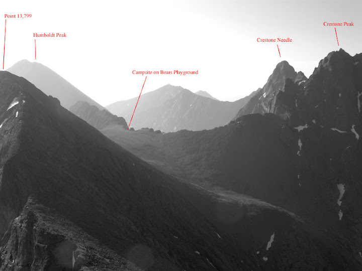
Looking back at the Crestones and the Playground from Columbia's east ridge.
We summited Columbia in no time. A plaque bolted to the summit memorialized the astronauts who died when Space Shuttle Columbia disintegrated in 2003. Idiot vandals had defaced President Bush's statement about the disaster.

The fun began after we topped off on Columbia. I started down climbing above the highest point of the saddle between Columbia and Carson. That section was a dead end without climbing gear. Luke found the correct route down farther to the left of Columbia's summit. The steep down climb was a lot of fun because the rock was bomb proof and holds were abundant. Exposure to heights focuses me more powerfully than deadlines or caffeine.
A solo hiker joined up with us just after we hiked onto Carson from the saddle. We climbed up through a talus field and then a rock face to reach Carson's summit.
 Looking up at Carson's summit from the east
From the summit we downclimbed to Kit Carson Avenue, a well-defined path that contours along the south face of Carson to the saddle between Carson and Challenger. We picked a line up the talus field on Challenger and reached its summit in short order. On the summit was a plaque in honor of the Challenger astronauts.
I made two harmless errors on the return to Bears Playground. As you hike below Columbia's summit on the Columbia-Carson saddle, you pass several pitches of rock before the stretch that you climb to reach the summit. I started climbing up a rocky gully that was 50 yards west of the correct route. Later, as we contoured around Columbia below the summit, Columbia's false east summit came into view and I mistook it for Point 13,799, which marks the west end of Bears Playground. Neither mistake cost us any time because Luke pointed out I was wrong on both counts.
 About to start the climb up Columbia from the saddle between Columbia and Carson.
 Half-way there.
When we reached the tent, I had drunk one liter of water for the day. I was parched, but my spirits were high. I had just noticed that gum tissue that had been swollen for six days no longer was inflamed or painful. This brought an end to my preoccupation with abscesses and brain infections. I savored the absence of pain and anxiety throughout the afternoon.
We broke down the camp. The plan was to hike back to the trailhead, camp, and make an attempt on Crestone Peak the following morning.
Luke felt adventurous and suggested that, instead of returning to the South Colony Lakes on the switchbacks below Humboldt's west ridge, we hike down a steep scree gully. I gulped and said I'd give it a shot. The gully we picked had to have been more than 35 degrees in grade. The scree was fine and loose; it flowed like water when you stepped on it and I set off more than a few mini-rock slides that rattled me. Negotiating that terrain while wearing a heavy pack was a dangerous test of my dexterity. The dexterity test continued after we reached the bottom of the gully. We traveled east through the basin in the direction of the trailhead by leaping from one huge boulder to another.
When we got back to the Highlander, thirst was driving me crazy. The first thing I did was to take the water filter over the South Colony Creek and treat and guzzle three liters of water. We made camp a few hundred feet up the trail from the parking lot. Luke cooked up burritos with scrambled eggs, red beans and rice, and grilled vegetables. As he cooked, it began to rain, and we scrambled to pitch my four season tent. The rain ended quickly. I gorged myself on the burritos.
After we stored the food and some gear in the Highlander, Luke produced his flask and we had a shot of cheap, 100-proof Canadian whiskey. Two friendly Indian guys who had just parked at the trailhead approached us. They had flown to Denver from Indianapolis that morning and had one day, Saturday, to attempt to summit Crestone Peak. They wanted to know if the REI in Colorado Springs was correct in claiming that they needed an ice ax and crampons for the climb. We said that other climbers had told us that crampons were handy but not essential. I offered them a pull of whiskey. They thanked me but declined the offer.
July 11, 2008
No comments:
Post a Comment