On Wednesday I flew from Chicago to Colorado Springs and drove a rented Toyota Highlander to Westcliffe, Luke's new home town. We took our maps over to a saloon on Main Street and hashed out the itinerary over a round of drinks. We planned to hike the Class 2 route up Humboldt Peak on Thursday, summit Kit Carson via the Class 3 route on its east ridge on Friday, and finish on Saturday by climbing Crestone Peak’s Red Couloir, a Class 3 route.
 The north slopes of Humboldt Peak from the South Colony Lakes trail.
 Around 7:00 a.m., we reached the parking lot. We planned to carry overnight packs up to 13,000 feet on Humboldt. Then we’d drop the heavy packs and summit Humboldt with day packs and water. On the way down, we’d grab the heavy packs and hike west on Humboldt's west flank to Bears Playground, a high saddle that connects Crestone Peak with Kit Carson. This would enable us to start the attack on Kit Carson from close range on Friday morning. Hiking steep terrain with a heavy pack at 13,000 feet was going to punish me since I was acclimated to sea level air. At the trailhead, Luke encouraged me to ditch anything that was arguably unnecessary. He thought my water filter was unnecessary since he was bringing a stove and iodine, so I left it in the Highlander.
We passed through the gate at the parking lot and began hiking west along the road that decades ago provided access to a mine below the lower South Colony. After a mile, the trail forked. The left (south) fork is the standard route for Crestone Peak and Crestone Needle. The right fork winds above the lower South Colony Lake at 11,800 feet to the valley's north wall. When I crossed a stream above the lower lake, my foot slipped on the stepping stone and I fell in. The hike was off to a brilliant start. A steep set of switchbacks ascend the north wall of the valley from around 12,000 feet to about 13,000 feet on Humboldt's west ridge. Saddled with a 50 pound pack and not acclimated to the thin air, I felt dizzy and sucked air hard while hiking the switchbacks. I counted each step and took a break each time the trail switched back. Luke moved farther ahead of me the entire time. I had gone two weeks without smoking and thought my lungs would be stronger.
I reached the top of the switchbacks five to ten minutes after Luke. The end of the exertion cheered me up, as if a sharp pain that had been dogging me abruptly vanished. We stopped for lunch. Luke had brought all the food we'd need on the trip. Lunch consisted of apples, peanut butter and honey sandwiches on Luke’s homemade sourdough bread, and his homemade power bars. The food was excellent.
The established trail had ended with the switchbacks. From the there, the route to Humboldt's summit entailed picking a line route through an immense talus field covering the peak's west ridge. I felt reborn without the overnight pack, but I still lagged. A twenty-something guy from Denver and his father overtook us below the summit. We reached the high point (elev. 14,064 feet) just after 11:30 a.m. We had covered 2.8 miles and 2,800 vertical feet in about 4 hours. This was Luke's first fourteener.
While descending the west ridge to the spot where we left our packs, we crossed paths with a guy who ascending Humboldt with his dog. Earlier that day, he and his dog had made it to the summit of Columbia Peak, which guards the approach to Kit Carson from the east. He didn't attempt to summit Kit Carson because his dog would not follow him when he began downclimbing to the the saddle between Columbia and Carson.
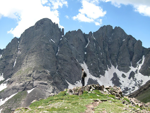 Luke stands on Humboldt's west ridge with Crestone Needle (on the left) and Crestone Peak (on the right) looming on the other side of the South Colony valley.
 Crestone Needle (center) and the Broken Hand Pass (left) seen from Humboldt's west ridge
To get from Humboldt to Bears Playground, we hiked along Humboldt's west ridge, which drops to around 13,000 feet and then climbs up to over 13,200 feet. There is no trail on the ridge. You pick a line and follow it. We climbed Class 3 boulders and rock faces in a few places. I did my best to keep up with Luke, who led the whole way. He has strong route finding skills, excellent judgment, and high endurance.
Bears Playground, at 13,200 feet, connects the northwest face of Crestone Peak, the west ridge of Humboldt, and the east ridge of Kit Carson. Mountain grass and wild flowers are the only vegetation. Crestone Peak soars above the Playground to the southeast. 700 feet below the Playground to the northeast lie the North Colony Lakes. 1,200 feet below, to the east, lie the South Colony Lakes. 1,000 feet below to the southwest is the Spanish Creek basin. Surrounded by the surpassing beauty of the mountains, I felt awe and reverence for the physical world.
 Crestone Peak towers over our tent.
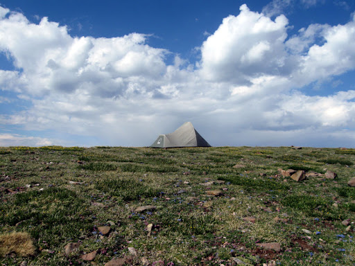
That tent has style.
 Colony Baldy from Bears Playground
It took us an hour to find a campsite. Using his ice ax as a pick, Luke dug up stones to make a smooth place to pitch his tent. I melted snow at the top of a gully that descended 800 feet to the South Colony basin. Luke thought melting the snow without boiling it would make drinkable water. I was so dehydrated I put aside my doubts and drank heartily. That water might have given me a case of giardia. That, or perhaps as likely, Chantix - the nicotine replacement drug I was taking - would scramble my gastrointestinal system for the six weeks after the hiking. After we had a massive spaghetti dinner, Luke hiked 700 feet down a steep snow field to the North Colony Lakes. At the uppermost North Colony, he made another three liters of water and treated them with iodine.
The altitude had decimated my strength. I didn't consider hiking down to the North Colonies with Luke. While he hiked, I read my camera manual and took photographs. The Playground was the visual equivalent of Beethoven's 7th Symphony. I felt a raw, overpowering love for life.
July 10, 2008
No comments:
Post a Comment