Friday, August 22, 2008

South Colony Lakes, Part III

On Saturday, we got up at 4:50 a.m. to climb the Red Couloir on the south face of Crestone Peak. This route climbs southwest from the trailhead at 11,200 feet to the Broken Hand Pass at 12,800 feet, and then descends switchbacks to Cottonwood Lake at 12,310 feet. From the lake, a cairned trail leads west around the south face of Crestone Needle to the base of the south face of Crestone Peak. The route gains a couple hundred feet via a series of switchbacks before climbing the Red Couloir for about 500 feet and reaching the saddle between Crestone Peak's east and west summits. The scramble from the saddle to the west summit is simple.

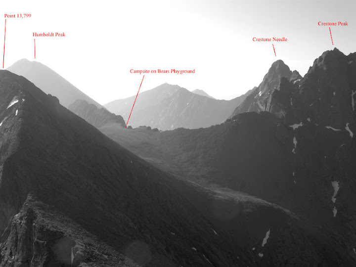
We hiked at a good clip and passed the Indians we'd met the previous night before we entered the bowl below the Broken Hand Pass. The bowl to the north of the Pass is mainly scree that is difficult to climb and supports no vegetation. We were lucky that much of the bowl was covered in fields of soft snow. There was a well-defined boot pack and getting purchase with our boots was easy.

Luke hikes one of the many snow fields on the way to Broken Hand Pass.

A beautiful alpine meadow awaited us on the south side of the Pass. The gentler slopes there allow mountain grass and flowers to grow. After descending steep switchbacks, we reached Cottonwood Lake. The sky was reflected in its still waters.


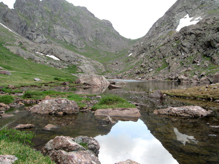
Cottonwood Lake seen from the west and from the Broken Hand Pass.

We followed the trail west to the base of Crestone Peak. The south face of the mountain rises up around 2,000 feet from grassy meadow below. We could see the Red Couloir extending several hundred feet from the middle of the south face to the saddle between the Peak's summits. From the base of the Peak, the Couloir looked too steep to be climbed without a rope.


A snow field extended down the Red Couloir from the saddle between the Peak's two summits.

We hiked switchbacks several hundred feet from the base to the increasingly steep rock of the Peak's southern face. The last cairn we saw was just east of Couloir. We figured we were entering the couloir at the right spot. We climbed along the west and east sides of the Couloir and at one point hiked up a steep field of rock hard snow. We had ice axes but no crampons. Luke asked me whether I would be able to self-arrest. I doubted I could. His question planted a seed of fear in me.

We got off the snow field and continued climbing to a point thirty or fifty feet below where the Couloir seemed to turn into cliffs that couldn't be climbed without protection. We exited the Couloir to the east and began scrambling up the rock face. We had no idea whether we were on route.

The face became steep enough that I doubted we could continue. Luke was more sanguine. While I sat tight, he climbed above me and moved beyond my range of vision. Five minutes later, he shouted down that he'd found a route that would take us back to the Couloir above the cliffs. Around the same time, I caught sight of the Indian climbers far below me. They noticed me and began shouting from several hundred feet below. I couldn't make out what they were saying and followed Luke's route without answering.

I climbed another 100 feet up. Then we moved west to re-enter the Couloir. The Couloir was a good 10 or 15 feet below the rock face. I got back to it by lowering myself down a natural stairwell between two large rocks. We eventually reached a long snow field that had been softened by the sun. Our boots got good purchase. After the snow field, we climbed a series of knobs and steps along the Couloir's east side. Then we reached the saddle between the two summits and climbed the short pitch to the west summit.

Two other climbers had already reached the summit. They told us they had made two previous unsuccesful attempts to summit Crestone Peak. They had spent a couple of hours that day doing route finding on the rock face east of the Couloir. Crestone Peak was certainly the most challenging mountain I'd done from a route-finding or exposure to heights perspective. The other climbers took our picture and then I took theirs. I cracked sarcastically that it would be the cover of the next issue of Outside.

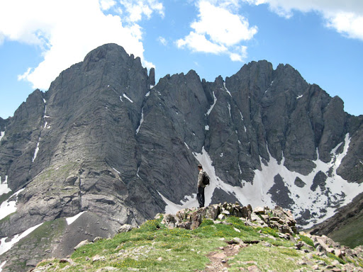
Luke and I on the summit. Crestone Needle is between us.

From left to right, Challenger, Kit Carson, and Columbia, seen from Crestone Peak.

On the descent, we encountered one of the Indians in the Couloir at an elevation around 13,500 feet. His partner had given up the hike because of altitude sickness. He had left his ice ax with the sick guy and continued up the Couloir alone. He asked whether he could safely continue. We said it was his call but it would be safer to return since he was solo and he had no ice ax. Also, it was almost noon, putting him in danger of getting caught by an afternoon rain that might make the rock unclimbable.

The Red Couloir during the descent. The lead Indian climber is in the upper left.

When we got back to the Broken Hand Pass, the leader of the climbers we met on the summit caught up with us. The Indian climber who had altitude sickness had postholed on a snowfield in the Couloir and got stuck. The leader Indian climber had dug him out with their shared ice ax. B
oth of them had made it out of the Couloir and down to the base of the Peak, which came as a relief to me.

Luke and I got back to the camp by 3:00 p.m. As we were driving down the Forest Service road back to Westcliffe, a terrific storm broke over the South Colony Lakes. Massive clouds moved in and thick tendrils of rain streamed down. Our timing was perfect.

July 12, 2008

Sunday, August 17, 2008

South Colony Lakes, Part II

Easterly winds coursing over the Playground battered the tent throughout Thursday night. A couple of times I thought the gusts would tear the fly off, but the tent held together. The temperature probably dropped into the 30s; my finger tips became numb and I gave up reading. At 5:00 a.m. on Friday, my wrist watch emitted a feeble beep that neither of us heard. We got up on our own at 6:00 a.m. and began hiking west along Bears Playground toward Kit Carson.

Carson is a complex mountain that comprises three distinct peaks: The east summit, Columbia, reaches 13,980 feet. The west summit, Challenger, reaches 14,080 feet. The true summit, Kit Carson, flanked by Challenger and Columbia, rises to 14,165 feet. To muddy the waters a little more, Columbia has a false summit east of its true summit. Most people hike up Carson's north face from the Willow Creek trail. The route from the east ridge, which we were taking, is hiked less often. Columbia guards against any approach from the east. You have to climb up Columbia and then downclimb 500-odd feet to the saddle between Carson and Columbia. Where to start downclimbing from the top of Columbia is non-obvious and the route down to the saddle is steep.

Point 13,799 marks the western end of Bears Playground. We contoured around Point 13,799 to the south of its summit and began hiking up the east ridge of Columbia. While we were on the east ridge, we heard coyotes howling from somewhere far below in the Spanish Creek basin.
Point 13, 799 is in the foreground. Columbia's east summit is behind it.

Looking back at the Crestones and the Playground from Columbia's east ridge.

We summited Columbia in no time. A plaque bolted to the summit memorialized the astronauts who died when Space Shuttle Columbia disintegrated in 2003. Idiot vandals had defaced President Bush's statement about the disaster.


The fun began after we topped off on Columbia. I started down climbing above the highest point of the saddle between Columbia and Carson. That section was a dead end without climbing gear. Luke found the correct route down farther to the left of Columbia's summit. The steep down climb was a lot of fun because the rock was bomb proof and holds were abundant. Exposure to heights focuses me more powerfully than deadlines or caffeine.

A solo hiker joined up with us just after we hiked onto Carson from the saddle. We climbed up through a talus field and then a rock face to reach Carson's summit.

Looking up at Carson's summit from the east

From the summit we downclimbed to Kit Carson Avenue, a well-defined path that contours along the south face of Carson to the saddle between Carson and Challenger. We picked a line up the talus field on Challenger and reached its summit in short order. On the summit was a plaque in honor of the Challenger astronauts.


I made two harmless errors on the return to Bears Playground. As you hike below Columbia's summit on the Columbia-Carson saddle, you pass several pitches of rock before the stretch that you climb to reach the summit. I started climbing up a rocky gully that was 50 yards west of the correct route. Later, as we contoured around Columbia below the summit, Columbia's false east summit came into view and I mistook it for Point 13,799, which marks the west end of Bears Playground. Neither mistake cost us any time because Luke pointed out I was wrong on both counts.

About to start the climb up Columbia from the saddle between Columbia and Carson.


Half-way there.

When we reached the tent, I had drunk one liter of water for the day. I was parched, but my spirits were high. I had just noticed that gum tissue that had been swollen for six days no longer was inflamed or painful. This brought an end to my preoccupation with abscesses and brain infections. I savored the absence of pain and anxiety throughout the afternoon.

We broke down the camp. The plan was to hike back to the trailhead, camp, and make an attempt on Crestone Peak the following morning.

Luke felt adventurous and suggested that, instead of returning to the South Colony Lakes on the switchbacks below Humboldt's west ridge, we hike down a steep scree gully. I gulped and said I'd give it a shot. The gully we picked had to have been more than 35 degrees in grade. The scree was fine and loose; it flowed like water when you stepped on it and I set off more than a few mini-rock slides that rattled me. Negotiating that terrain while wearing a heavy pack was a dangerous test of my dexterity. The dexterity test continued after we reached the bottom of the gully. We traveled east through the basin in the direction of the trailhead by leaping from one huge boulder to another.

When we got back to the Highlander, thirst was driving me crazy. The first thing I did was to take the water filter over the South Colony Creek and treat and guzzle three liters of water. We made camp a few hundred feet up the trail from the parking lot. Luke cooked up burritos with scrambled eggs, red beans and rice, and grilled vegetables. As he cooked, it began to rain, and we scrambled to pitch my four season tent. The rain ended quickly. I gorged myself on the burritos.

After we stored the food and some gear in the Highlander, Luke produced his flask and we had a shot of cheap, 100-proof Canadian whiskey. Two friendly Indian guys who had just parked at the trailhead approached us. They had flown to Denver from Indianapolis that morning and had one day, Saturday, to attempt to summit Crestone Peak. They wanted to know if the REI in Colorado Springs was correct in claiming that they needed an ice ax and crampons for the climb. We said that other climbers had told us that crampons were handy but not essential. I offered them a pull of whiskey. They thanked me but declined the offer.

July 11, 2008

South Colony Lakes, Part I

In March 2008, Luke moved to an old mining town just east of the Sangre de Cristos, the southernmost subrange of the Rocky Mountains. I was sorry to see him leave Oregon as it was handy to have a friend who lived an hour away from Mt. Hood. After doing a few early spring hikes in the Sangres, Luke declared them as impressive as any volcano in the Cascades. He and I made plans to hike three fourteeners in the South Colony Lakes area in July.

On Wednesday I flew from Chicago to Colorado Springs and drove a rented Toyota Highlander to Westcliffe, Luke's new home town. We took our maps over to a saloon on Main Street and hashed out the itinerary over a round of drinks. We planned to hike the Class 2 route up Humboldt Peak on Thursday, summit Kit Carson via the Class 3 route on its east ridge on Friday, and finish on Saturday by climbing Crestone Peak’s Red Couloir, a Class 3 route.

The north slopes of Humboldt Peak from the South Colony Lakes trail.

Around 6:00 a.m. on Thursday, after a mountain breakfast of pancakes and eggs, we started driving to the upper trailhead at South Colony Lakes. The last five miles of Forest Service Road 120, which accesses the upper trailhead at 11,200 feet, are four-wheel-drive-only. In between the half dozen stream crossings, the road is covered with deep ruts and big rocks. The Highlander scraped bottom several times although I drove at a snail’s pace.

Around 7:00 a.m., we reached the parking lot. We planned to carry overnight packs up to 13,000 feet on Humboldt. Then we’d drop the heavy packs and summit Humboldt with day packs and water. On the way down, we’d grab the heavy packs and hike west on Humboldt's west flank to Bears Playground, a high saddle that connects Crestone Peak with Kit Carson. This would enable us to start the attack on Kit Carson from close range on Friday morning. Hiking steep terrain with a heavy pack at 13,000 feet was going to punish me since I was acclimated to sea level air. At the trailhead, Luke encouraged me to ditch anything that was arguably unnecessary. He thought my water filter was unnecessary since he was bringing a stove and iodine, so I left it in the Highlander.


We passed through the gate at the parking lot and began hiking west along the road that decades ago provided access to a mine below the lower South Colony. After a mile, the trail forked. The left (south) fork is the standard route for Crestone Peak and Crestone Needle. The right fork winds above the lower South Colony Lake at 11,800 feet to the valley's north wall. When I crossed a stream above the lower lake, my foot slipped on the stepping stone and I fell in. The hike was off to a brilliant start. A steep set of switchbacks ascend the north wall of the valley from around 12,000 feet to about 13,000 feet on Humboldt's west ridge. Saddled with a 50 pound pack and not acclimated to the thin air, I felt dizzy and sucked air hard while hiking the switchbacks. I counted each step and took a break each time the trail switched back. Luke moved farther ahead of me the entire time. I had gone two weeks without smoking and thought my lungs would be stronger.

I reached the top of the switchbacks five to ten minutes after Luke. The end of the exertion cheered me up, as if a sharp pain that had been dogging me abruptly vanished. We stopped for lunch. Luke had brought all the food we'd need on the trip. Lunch consisted of apples, peanut butter and honey sandwiches on Luke’s homemade sourdough bread, and his homemade power bars. The food was excellent.

The established trail had ended with the switchbacks. From the there, the route to Humboldt's summit entailed picking a line route through an immense talus field covering the peak's west ridge. I felt reborn without the overnight pack, but I still lagged. A twenty-something guy from Denver and his father overtook us below the summit. We reached the high point (elev. 14,064 feet) just after 11:30 a.m. We had covered 2.8 miles and 2,800 vertical feet in about 4 hours. This was Luke's first fourteener.

While descending the west ridge
to the spot where we left our packs, we crossed paths with a guy who ascending Humboldt with his dog. Earlier that day, he and his dog had made it to the summit of Columbia Peak, which guards the approach to Kit Carson from the east. He didn't attempt to summit Kit Carson because his dog would not follow him when he began downclimbing to the the saddle between Columbia and Carson.

Luke stands on Humboldt's west ridge with Crestone Needle (on the left) and Crestone Peak (on the right) looming on the other side of the South Colony valley.

Crestone Needle (center) and the Broken Hand Pass (left) seen from Humboldt's west ridge

To get from Humboldt to Bears Playground, we hiked along Humboldt's west ridge, which drops to around 13,000 feet and then climbs up to over 13,200 feet. There is no trail on the ridge. You pick a line and follow it. We climbed Class 3 boulders and rock faces in a few places. I did my best to keep up with Luke, who led the whole way. He has strong route finding skills, excellent judgment, and high endurance.


Bears Playground, at 13,200 feet, connects the northwest face of Crestone Peak, the west ridge of Humboldt, and the east ridge of Kit Carson. Mountain grass and wild flowers are the only vegetation. Crestone Peak soars above the Playground to the southeast. 700 feet below the Playground to the northeast lie the North Colony Lakes. 1,200 feet below, to the east, lie the South Colony Lakes. 1,000 feet below to the southwest is the Spanish Creek basin. Surrounded by the surpassing beauty of the mountains, I felt
awe and reverence for the physical world.


Crestone Peak towers over our tent.

That tent has style.

Colony Baldy from Bears Playground

It took us an hour to find a campsite. Using his ice ax as a pick, Luke dug up stones to make a smooth place to pitch his tent. I melted snow at the top of a gully that descended 800 feet to the South Colony basin. Luke thought melting the snow without boiling it would make drinkable water. I was so dehydrated I put aside my doubts and drank heartily. That water might have given me a case of giardia. That, or perhaps as likely, Chantix - the nicotine replacement drug I was taking - would scramble my gastrointestinal system for the six weeks after the hiking. After we had a massive spaghetti dinner, Luke hiked 700 feet down a steep snow field to the North Colony Lakes. At the uppermost North Colony, he made another three liters of water and treated them with iodine.

The altitude had decimated my strength. I didn't consider hiking down to the North Colonies with Luke. While he hiked, I read my camera manual and took photographs. The Playground was the visual equivalent of Beethoven's 7th Symphony. I felt a raw, overpowering love for life.

July 10, 2008